Airbus Launches Wildfire Sentinel to Interconnect Front Line Firefighters
Airbus demonstrates connected, AI-driven wildfire response platform combining drones, helicopters, satellites and ground forces in landmark trial at Nîmes, France.
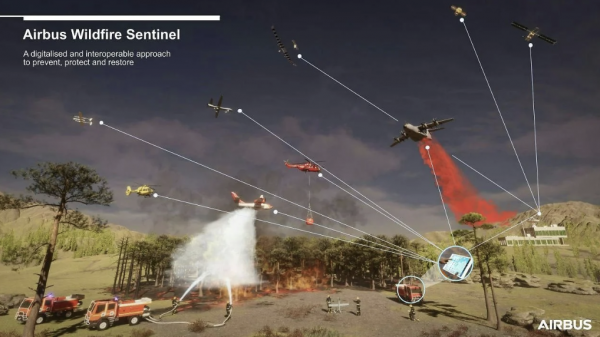
Airbus has unveiled the Wildfire Sentinel, a holistic data-driven firefighting ecosystem designed to connect aerial and ground resources in real time, dramatically accelerating wildfire detection and suppression. Tested in March 2026 at the Garrigues military camp near Nîmes, southern France, the trial brought together an Airbus H130 Flightlab helicopter, an ATR 72, a Cirrus SR20, four drones including the Airbus Aliaca uncrewed aerial system, and three firetrucks from the Departmental Fire and Rescue Service of Le Gard.
The Wildfire Sentinel combines Airbus technology across aircraft, communications and flight operations with solutions from partner companies. Its core capabilities centre on seamless data exchange via the Agnet collaboration platform and real-time tactical situation awareness. By aggregating optical imagery from light aircraft and UAS with Earth observation satellite data and terrain mapping, the system applies AI-enabled processing to deliver a comprehensive tactical picture to all stakeholders simultaneously.
A key challenge in wildfire management is the information lag that allows small brush fires to grow out of control before resources can be deployed. The Wildfire Sentinel addresses this directly by connecting satellite surveillance to a tactical command network, automatically incorporating wind speed, direction and the exact positioning of emergency response teams into a dynamic operational map. During the Nîmes trial, highly accurate water drops were executed within minutes of a simulated wildfire ignition, demonstrating that digital connectivity can materially reduce the critical window between detecting a spark and delivering the first drop of water.
"Airbus' ambition is to build an ecosystem that will answer the new challenges of managing wildfires in a more extreme environment," said Oliver Chalvet, Senior Manager for Firefighting Solutions at Airbus Defence and Space.
The platform also eliminates reliance on fragmented radio communications, replacing them with a unified, high-definition digital map of every drone, aircraft and ground crew operating in the field.
"We connect aerial resources with ground assets using geolocation, observation data, and an integrated database accessible to all stakeholders," explained Thierry Fol, Head of the Airbus Flightlab.
"In this way, the firefighter commander no longer has to rely on fragmented radio calls. Thanks to Agnet they see a real-time, high-definition digital map of every drone, aircraft and ground crew, ensuring total situational awareness even in the most disconnected environments."
 The urgency of such capability is underscored by the scale of the global wildfire crisis. In 2025, Earth observation satellite data recorded approximately 390 million hectares of fire-affected land globally, equivalent to roughly 92 percent of the entire land area of the European Union. With wildfire seasons growing longer and more extreme, the Wildfire Sentinel represents a significant step forward in the industry's ability to protect ecosystems, communities and lives.